
Our Services
Basic Plan
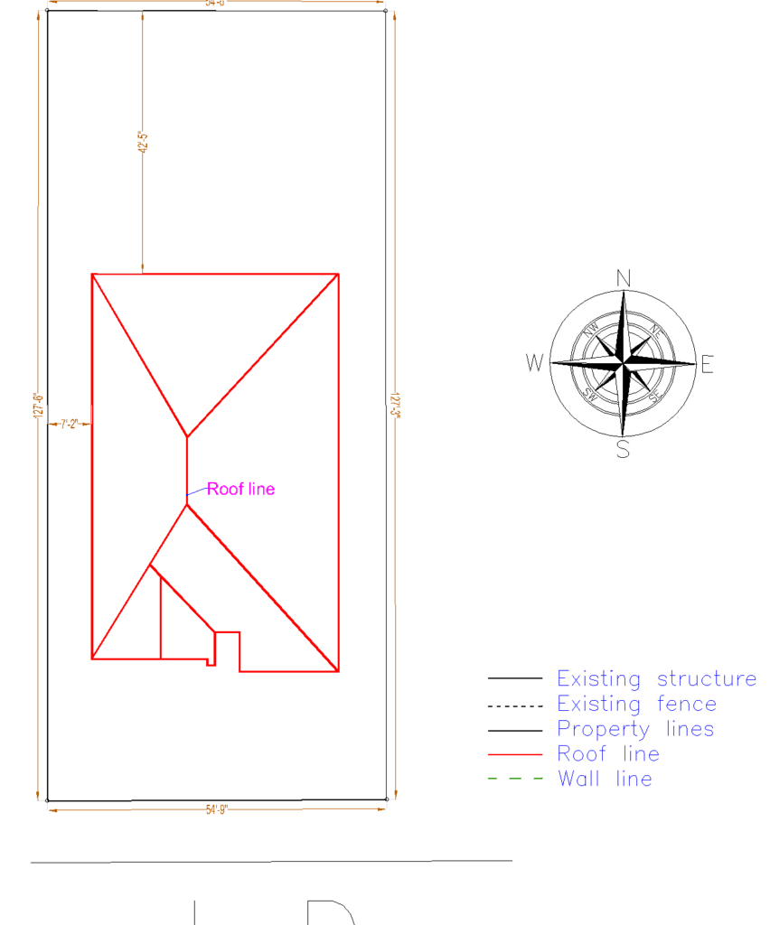
You will receive an overview of your land with our Basic Plan. To create a draft site design, we will make use of satellite imagery and GIS.
- Content:
- * Existing Property Lines
- *Measurements between features
- *North Arrow
- *Lot Dimensions
- *Primary Structure
You will be able to confirm measurements and annotate the draft site plan with any necessary changes when we provide it to you for review. We will take care of any necessary changes at no additional cost to you.
Typical Uses:
- Overall concept of the property
- Create a tool to assist you in developing your own landscape concepts
- Event planning
Premium Plan
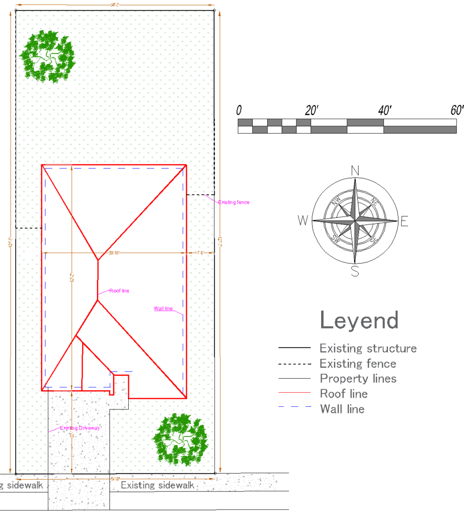
This package creates a site plan for your property based on the most recent satellite imagery available, GIS data, and any information provided by the customer.
It includes:
- Basic plan +
- Existing Trees
- Existing Swimming pool
- Existing Driveway
- Existing Accessory structures
We will send you the first draft of the site plan for review. You can sketch any required changes on the design and send it back to us for a free revision if any are needed, including updating measurements or adding items that are missing because of tree cover.
Example of use:
- *Event Planning
- *Landscape Design
- *Request Construction permits for new outside structures (concrete patios, gazebos, trash screen fences)
- *Applying for demolition permits for homes or other structures
- *Formulate yard work schedules, highlight the directions to reduce misunderstandings
- *Building permission applications in cities with tree preservation regulations
Elite Plan
This plan will provide a higher degree of information for permits regarding residential properties.
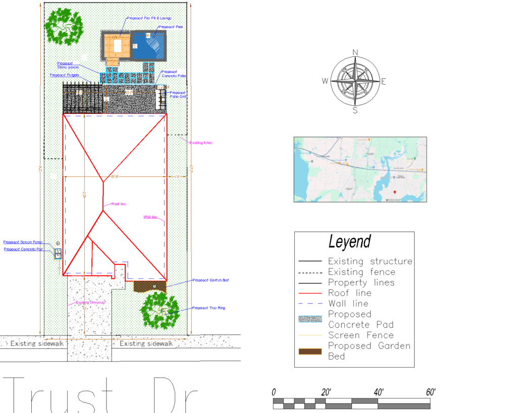
We will create a comprehensive site plan of your property that includes every aspect of the landscaping that is currently in place (as seen by satellite), including:
- Premium plan plus
- Existing Parking Spaces
- Existing Paths
- Existing Shrubs
- Existing Lawn
- Existing Landscape
You will receive a draft site plan to evaluate. You can draw any necessary revisions onto the design and send it back to us for a free revision if there are any missing things from tree cover or updated measurements that need to be made.
Examples of Uses
- * Applying for a building permit for a new outdoor structure (Shed, gazebo, fence etc.)
- *Applying for a demolition permit for the demolition of your house or another structure
- *A swimming pool removal or remodel
- *A road map for having yard word done. Mark up your instructions to avoid any confusion.
- *Conditional Use Permit for Commercial Properties
- *Thinking of re-doing your landscape? Start with this plan to begin your process of what to keep and what to eliminate

Subdivision Site Plan – Fast, Simple & Ready for Approval
Need to turn one parcel into multiple buildable lots—quickly and without the headache?
We’ve got you covered.
Subdivision Plan in 2–5 Business Days
From your first rough sketch to a polished final plat, we streamline the entire process so your subdivision site plan is clear, and easily approved.
-Smooth approval process
-Clear, buildable lot layout
-Meets all local subdivision standards
-100% approval guarantee—or your money back
Drafting service only: Plans are non-certified and not intended as a legal survey. Make sure your city or county does not require a stamped plan.
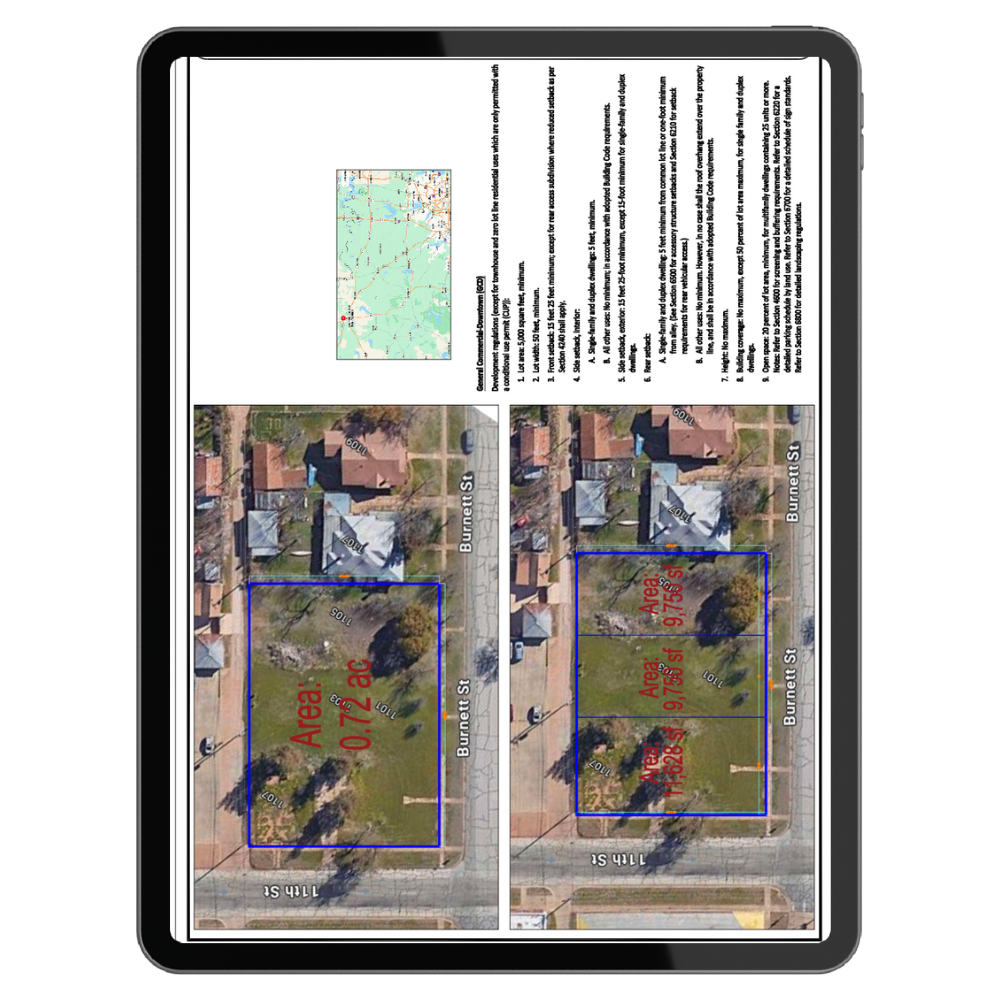
What Is a Subdivision Site Plan?
A subdivision plan shows how a single parcel will be divided into new lots, including proposed lot lines and any improvements like roads, utilities, or easements.
Cities and counties use this plan for permitting, planning board reviews, and recording new lots.
What’s Included
Your plan comes complete with:
- -Lot layout: new property lines, measurements & setbacks
- -Building footprints: homes, garages, decks, sheds
- -Infrastructure: roads, driveways, utilities, sidewalks
- -Topography: contours (where available) to show slopes
- -Landscaping & open space: trees, buffers, easements
- -Reference details: scale, north arrow, vicinity map, parcel ID
- -Digital files: PDF (print-ready)
Perfect For
- Creating two or more lots from one parcel
- Sketch, preliminary, or final plat submissions
- Projects adding roads, utilities, or site improvements
How It Works
- Choose your plan.
- Select the subdivision plan and include all the info you think is important.
- Send us your property info.
- Share the address or parcel number and upload any sketches, surveys, or zoning details.
- Receive your plan.
- Get your completed subdivision plan (PDF, DWG & JPG) in1–5 business days.
What We Need From You
- -Property address & parcel number
- -A rough sketch of how you want to split the lots (hand-drawn is fine)
- -Any existing survey or topographic data (if available)
- -Local zoning/subdivision requirements (setbacks, minimum lot size, etc.)
Don’t have a clue on how to subdivide the lot or where to get the zoning info? No worries—we can handle that for you. Request a custom quote.
Turnaround Time
- Standard parcels (up to 5 acres): 1–5 business days
- Larger or complex sites: custom quote required
Why Choose Us?
- -Fast turnaround – typically within 48 hours
- -No surprise revision fees
- -100% approval guarantee – free revisions or full refund if rejected
Important Reminder
- We provide a drafting service, not a legal survey. Our plans are non-certified. Always confirm whether your jurisdiction requires a licensed surveyor, engineer, or architect.
- Most of the government offices (City & Counties) accept non-certified plan for preliminary review. However, we always recommend double-checking with your planning office.
- How many revisions are included?
- Two revision are includes – rounds of minor edits (text, dimensions, layout tweaks) within 14 days—free.
- We do subdivisions on parcels over 5 acres – request a custom quote.
Check List for Plan info
Find out what will you get with each plan
Basic Plan
$89
Unique Pay
- Property Lines
- Primary Structure
- Lot Dimensions
- North Arrow
- Scale
- Measurements Between Features
Premium Plan
$119
Unique Pay
- Property Lines
- Primary Structure
- Lot Dimensions
- North Arrow
- Scale
- Measurements Between Features
- Trees
- Driveway
- Accessory Structures
- Swimming Pool
Elite Plan
$159
Unique Pay
- Property Lines
- Primary Structure
- Lot Dimensions
- North Arrow
- Scale
- Measurements Between Features
- Trees
- Driveway
- Accessory Structures
- Swimming Pool
- Parking Spaces
- Paths
- Shrubs
- Lawn
- Landscape
Lot Subdivision
$359
Unique Pay
- Property Lines
- Primary Structure
- Lot Dimensions
- North Arrow
- Scale
- Measurements Between Features
- Trees
- Driveway
- Accessory Structures
- Swimming Pool
- Parking Spaces
- Paths
- Shrubs
- Lawn
- Landscape
- Vicinity Map
- Graphic scale
- DWG
Additional Project Pricing
(ver siguiente)
- Add new structures (EA) — $15.00 (premium and elite plan only)
- Vicinity Map — $20.00
- Graphic scale — $10.00
- DWG — $20.00
- JPG — $20.00
- Custom paper Size Request — $10.00
- Rush Order Site plan less than 12 hours — $40.00

Site Plan Solutions, we specialize in providing comprehensive and innovative site plans to help our clients to get the permits they need for their projects
